Showing posts with label hiking. Show all posts

Saturday, July 1, 2017

Mount Princeton


Mount Princeton's summit sits at 14,196'. We set out to hike Mount Princeton thinking it would be relatively easy since you can drive to nearly 11,000'.


The hike kicked our butts though! The dramatic mountain is nearly all rock talus and loose scree fields. There were numerous snow crossings across steep pitches. It took us all day to get up and down this challenging first fourteener of the season. Rio and Loki were hurting from walking on the rocks all day - and they were both happy and relieved to rest in the snow fields and alpine tundra.


Sunday, April 30, 2017

San Rafael Swell


Exploring new places is one of my favorite activities. I love to find hidden gems and magical, new locations. On this trip, we wandered through slot canyons, stood in wonder in front of ancient rock art, and found water in the middle of the desert. I'd say it was quite a successful long weekend.


But, as always, nothing is ever perfect. We did try to take a long "short-cut" that ended in a washed-out, impassable road. We had to turn around and backtrack - so much for the short-cut. And finally, we popped a tire toward the end of the day, ultimately driving home a bit more slowly on a spare. And so it goes.  


Saturday, August 13, 2016

Capitol Peak

I'm WAY too big of a chicken to climb this mountain, but my husband hiked it with some friends and the GoPro footage is incredible (and terrifying)! Check it out! 


Gosh! Between those camera angles and that commentary, I bet you're speechless right now! :)


Thursday, July 14, 2016

Conundrum Hot Springs

Conundrum Hot Springs: a magical place overrun by partying backpackers. 

What an incredibly stunning, picturesque, unique treasure that is currently trashed. We must have passed one hundred people - give or take - hiking out as we were hiking in. And I feel I should mention this was on a Thursday. We timed it right though, and had the hot spring to ourselves for almost an hour in the middle of the day during the transition of hikers departing and arriving. 


As night fell, every campsite in the vicinity filled up, as did the hot springs. Hopefully we can all learn to take care of the magical natural places that we love to visit and spend time in. 

Monday, July 4, 2016

Four Pass Loop

Ahh, the iconic Four Pass Loop! We set out to complete this 26 mile loop in 3 days, beginning at the Maroon Bells and hiking counter-clockwise over all four picturesque passes. While backpacking breathes an air of solitude, the Four Pass Loop surely did not. It is one of the most popular magical places I've backpacked in.


The trip seemed a lost cause when I woke up ill the night before our departure. It delayed our start significantly; however, by 11:00am we were hiking up toward Buckskin Pass in a misty drizzle before finding a campsite nestled in some trees just below the pass. We didn't make it far that first day, but listening to the rain hit the tent fly as afternoon turned into night was both healing and rejuvenating.


Each day thereafter consisted of snow crossings, pass climbing and a lot of rain. The low clouds blocked the views of distant peaks, but they cloaked the passes and meadows in still, quiet, eerie mystery.


On our last day, we awoke to blue skies. We welcomed the change in weather and as the sun recharged us, we made our way over West Maroon Pass - the final pass of the trip.


Monday, June 20, 2016

West Elk Loop

Setting off on the first backpack trip of the season, we made our way up Kebler Pass to Horse Park (Cliff Creek Trail) and began our hike into the West Elk Wilderness. The trail was beautiful right off the bat, and we were greeted by some beautiful grazing deer. We made good time to Beckwith Pass, where we took a break to soak up the views. Four people on horseback passed us here on their way to Beckwith Bench, which sounds like a great hike, too.


After our break, we continued on toward Cliff Creek Trail. At some point, we lost the trail completely and found ourselves on a game trail. After much consultation with the compass, map and GPS, we discovered we were below the trail; we hike straight up what felt like a mountain and were relieved to reconnect with the trail. The trail was very muddy in spots, allowing and severely highlighting animal tracks. I kept finding bear tracks, and I began to get nervous. Around 5:30, we were pulling into the area we wanted to camp in, and, as I rounded the corner I heard two loud grunty, breathy, deep snorts or barks from the bushes. I hollered ahead to Justin, who came back, but thought maybe it was just a deer bounding away.


I had a sinking feeling that those snorts came from a bear, however. We began to set up camp in a beautiful meadow and cook dinner. Just as dinner was ready, I looked up, and saw a bear. The bear was about a hundred yards away, he was, grazing and sniffing the air while, all the while, watching us. This was my first real encounter with a bear, so naturally, I overreacted. I watched in a panic for close to an hour as the bear lingered beyond our camp. As the sun began to set, the bear sauntered off in the opposite direction of us, but I decided we just couldn't sleep there. We packed everything up, and hiked about another mile before setting up our tent in the dark. I didn't get much sleep that night.


The next morning, we hiked up to Sheep Lake, an out-and-back trail off of our loop. We spent some time at the lake snacking and filling water, before realizing we still had 6 miles to hike that day. We didn't realize two of those six would be through snowfields. We connected in with the Castle Pass Trail, which had some truly amazing views, and began our track up to the highest point of our trip, 11,000 feet. We anticipated some snow, but what we found was certainly more than we were hoping for. Justin post-holed us a trail for nearly two miles through deep snowfields. He was determined to make it over Castle Pass.


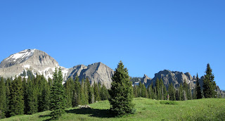
Our feet were sopping wet by the time we made it over the pass, and we were relieved to be heading back down into lower elevation. The views of the Castles from the other side of the pass were magnificent. We made it into a beautiful basin, and decided to set up camp for the night.


On our last day, we hiked up and over Swampy Pass and back over Beckwith Pass before descending back to Kebler Pass. Overall, the trip was 29 miles long with roughly 5000 feet of elevation gain. The path we took was from Horse Ranch Park (Cliff Creek Trail) to Beckwith Pass to Cliff Creek Trail to Castle Pass to Lowline Trail back to Beckwith. I highly recommend the trip as an early or late season backpack, as I hear it is a popular grazing area for livestock in the summer months.


Saturday, October 24, 2015

Morning Glory

As October was nearing an end, we loaded up the vansion for one last desert "hoorah" before winter. We drove into Moab and found a campsite nestled in among ancient dinosaur bones and history.


We decided to hike to Morning Glory Natural Bridge, well, us and at least a hundred of our closest friends. The hike was absurdly busy, as most hikes in Moab are these days, but still lovely. There was an abundance of water, which the dogs were happy about. The trail follows a creek for a good while with several crossings.


We made it to Morning Glory Natural Bridge just in time to see a group repelling down from above. Although it wasn't the most peaceful hike and a feeling of solitude was seemingly nonexistent, it was still a great way to celebrate the changing season and soak up the last bit of warmth the desert had to offered.

Saturday, September 26, 2015

Leaf Peepin'

Fall is a magical season, and every year, one of my favorite seasonal activities is leaf peeping. This year, we decided to pack up the vansion and head up Kebler Pass in search of golden leaves.


It was the perfect weekend to view the changing colors, but we were certainly not the only ones who decided that. Kebler Pass was busy and crowded with photographers and others out to see the stunning colors for themselves.


We found a campsite at the way to Lost Lake and enjoyed an crisp evening under a late September sky. The next day, we drove further up Kebler Pass to Lake Irwin, which was super crowded. Once we were past the lake, however, we pulled off the road and hiked up to Green Lake. We only passed a few people on the hike and were able to get beautiful views of the valley.


Sunday, September 6, 2015

La Plata Peak

La Plata Peak is the fifth highest peak in Colorado with a summit reaching 14,336 feet. It has been one of my favorite fourteener hikes to date.


October was looming in the distance, and my husband and I decided we needed to head out for one more peak summit of the season. My sister was looking for a birthday adventure, and since this was her birthday weekend, she decided a summit was in order for her, too.


We arrived at the trailhead before sunrise and were surprised by how many cars were already there. With access just off on Independence Pass, this is a popular hike. After about an hour, we were greeted with a brilliant sunrise, which gave us a much-needed energy boost.


The wind began picking up as we neared the summit, and we were wearing all of our layers by the time we reached the top. It was worth it though; the views were spectacular and the smiles were bigger than ever.

Sunday, August 2, 2015

Missouri Mountain and Clear Creek Campout

With summer nearing an end, my husband realized we had yet to camp with our families this summer. We quickly called everyone and made a plan to meet up Clear Creek Road outside of Buena Vista for a weekend campout.


Justin's sister and I began plotting an additional adventure which required us to meet a day early and climb a fourteener, Missouri Mountain (14, 067'). Missouri Mountain is a ten-mile round trip hike with 4, 500 feet of elevation gain. We set a date, and met for the hike. My sister and two friends also decided to join, making us a party of 5 strong women and 2 dogs.


Our alarm clocks went off at 4:00 am, and we huddled around the stove to make coffee. We were on the trail by 5:30, making good time up to Missouri Mountain's summit. The trail was great and well-maintained; we even passed by the Colorado 14er Initiative Group working on the trail. Once at the scree field, however, the trail became steep with loose gravel. We took our time and made it to the ridge quickly. The ridge is exceptionally long and beautiful, and I enjoyed walking the spine until I saw the final scramble, which required a bit of climbing. The guidebook calls this a class 2 climb, and it didn't say anything about any climbing - or scrambling for that matter.


Unfortunately, Loki (my puppy) and I didn't feel like we could maneuver the climb together, so we stayed back and didn't reach the true summit that day. We did, however, enjoy the beautiful views on our very private "false summit," only feet lower than the actual summit.


After the hike, my friends left and my family arrived. The next day we took our stand-up paddle boards down the road to Clear Creek Reservoir and played around. My mom and mother-in-law took to the boards and had a blast. That night, we roasted marshmallows and enjoyed some family time.


Sunday, June 28, 2015

Mount Belford

To celebrate our second wedding anniversary, my husband and I decided to climb a mountain. Late June is still pretty early for mountain climbing, especially with all the late season moisture we got this winter, but we decided we would go for it anyways.


We chose Mount Belford (14,067'), accessible down Clear Creek Road outside of Buena Vista, Colorado. We arrived late Friday night and camped right off the road about a mile past the trailhead. With seven miles and 4,000 feet of elevation gain ahead of us, we went to bed early that evening.


In the morning, we got an early start, hiking the first mile and a half of switchbacks in the dark. The water crossing was very high, so we took a half-mile detour to see if there was a better spot to cross - there's not! So we took off our shoes and crossed the icy knee-deep water. After the water crossing we quickly made it to tree-line and began our ascent of Mount Belford.


We saw several other groups on the trail, but the mountain wasn't too busy. We made it to the top in time for lunch, but the clouds started building around us. We decided not to bag two peaks in one day, and we left Mount Oxford for another day.


I was grateful for the icy water crossing on the way down because my feet were sore from the first fourteener of the season. After a wonderful hike, we made it back to van-trouble; it wouldn't start. It turns out we had jostled the battery lose on the washboard road. Luckily, Justin had it up and running with enough time for us to make our dinner reservation at Mount Princeton Hot Springs. Of course, we soaked in the over-priced hot springs, too.


It was a wonderful anniversary, and I am looking forward to many more adventures to come.

Saturday, May 16, 2015

Mount Garfield

Mount Garfield is an iconic desert highpoint seen from i70 on the drive to or from Grand Junction. Not knowing much about the hike, it had been on my list of adventures for a while. My husband agreed to hike it one Sunday on our way back to Carbondale.


We found the trailhead easily. Justin didn't heed the warning posted before the highway underpass; however, and we ended up driving through a pool of water that was nearly high enough to reach the van doors. He punched it through the standing water while I yelled at him (oops!); it's safe to say I was a bit shaken up upon starting the hike.


Mount Garfield is a four-mile round trip hike with 2000 feet of elevation gain. We began hiking up the STEEP spine section - pausing nearly every fifty feet to catch our breath. I felt the onset of vertigo just as we were reaching the end of the spine, thankfully. After the spine the hike is moderate with several more ups and even a couple of flat sections.


We made it to the top and enjoyed the view just as the rain clouds began rolling in. We snapped a couple of photos and headed down quickly. We made it safely across the underpass ravine again, and then we were homeward bound.


Saturday, September 20, 2014

Aspen to Crested Butte for Vinotok

For my birthday, some friends and I decided to hike 12 stunning miles from Aspen to Crested Butte on West Maroon Pass. We began our journey at 5:00 am, hoping to avoid the crowds of tourists that tend to gather at the Maroon Bells - and we did just that.


It wasn't until we began ascending West Maroon Pass that we saw other people on the trail. The top of the pass revealed remarkable views of the surrounding valleys that reached toward Aspen and Crested Butte. It was a beautiful fall day, and we lingered quite a while on top of West Maroon Pass.


The descent was quick and in a short amount of time we found ourselves back in the trees. We popped out of the trees into the parking lot about six hours after we began hiking that morning. We enjoyed a cold beer and some lunch before piling into the vansion and heading into town for the Vinotok Festival.


Vinotok proved to be even weirder than expected. I treasure small towns, free spirits and wacky festivals.

Thursday, September 11, 2014

Saturday Sopris Summit

"The early bird gets the summit," is the mantra I repeated to myself as I rolled out of bed at 2:30 am. Hitting the trail at 3:00 am was rough, and even though there was a full moon, we still needed headlamps. The trail was rocky and hiking it in the dark was not ideal, but we hiked on.


Finding ourselves above tree-line as the sun began to rise made hiking in the dark for 3 hours totally worth it! It was a magnificent sunrise; one I won't ever forget.


Sopris defeated me last summer, and I was determined to summit that stubborn mountain this summer. From the trailhead to the summit the hike is around 13 miles roundtrip. When you combine that with the intense elevation gain it makes for a really long day. The summit of Mount Sopris stands at 12,966' high.


We reached the summit around 9:00 am, and were happily surprised by the lack of wind - and people! We spent an hour alone on the summit of Mount Sopris sharing snacks and celebratory beer!


We began our decent at 10:00 am and were thrilled when we made it to Thomas Lakes around noon. We took a long break at the lakes and as the storm clouds began rolling in we decided to keep heading down to the car.


The last 2 1/2 miles of the hike felt like an eternity, but we kept trucking none-the-less. It was the perfect Saturday to summit Sopris, and I couldn't be more excited to have made it to the top!